Geospatial Analysis for Development (Geo4Dev) Summer 2022 Workshop Series

The Bosphorus Strait splits the night lights of Istanbul, Turkey| Photo Credit: NASA Johnson, Flickr
Geospatial Analysis for Development (Geo4Dev) Summer 2022 Workshop Series
The Geospatial Analysis for Development (Geo4Dev) initiative held its second workshop of 2022 on July 20th at UC Berkeley. During these workshops, instructors walked participants through two of our Geo4Dev learning modules– Subways and Crop Type Mapping. Participants learned how to use open-source satellite data and novel geospatial analysis tools to address important questions related to international development. The workshops help students and faculty integrate geospatial into their research, and help practitioners at NGOs, government agencies and industry integrate geospatial analytics into their decision-making processes.
This is the second of our 2022 Geo4Dev Workshops. Video from all our workshops will be embedded in the relevant Geo4Dev tutorial.
Agenda:
Using a global subways dataset and radiance calibrated nighttime lights to analyze urban growth
Marco Gonzalez-Navarro (9:30 AM – 11:30 AM Pacific Time)
Participants ran through code to import subway data, select locations or stations of interest, create summary statistics, and build maps and graphical visualizations, and learn how to access and manipulate data from sensors calibrated to avoid saturation of urban centers. This workshop draws on two Geo4Dev tutorials developed from Marco Gonzalez-Navarro and Matthew Turner’s use of radiance calibrated nighttime lights and a global geolocated subways dataset in their paper “Subways and Urban Growth: Evidence from Earth“ (2018).
Crop type mapping using satellite data
Shruti Jain & Vivek Sakhrani (12:30 PM – 2:30 PM Pacific Time)
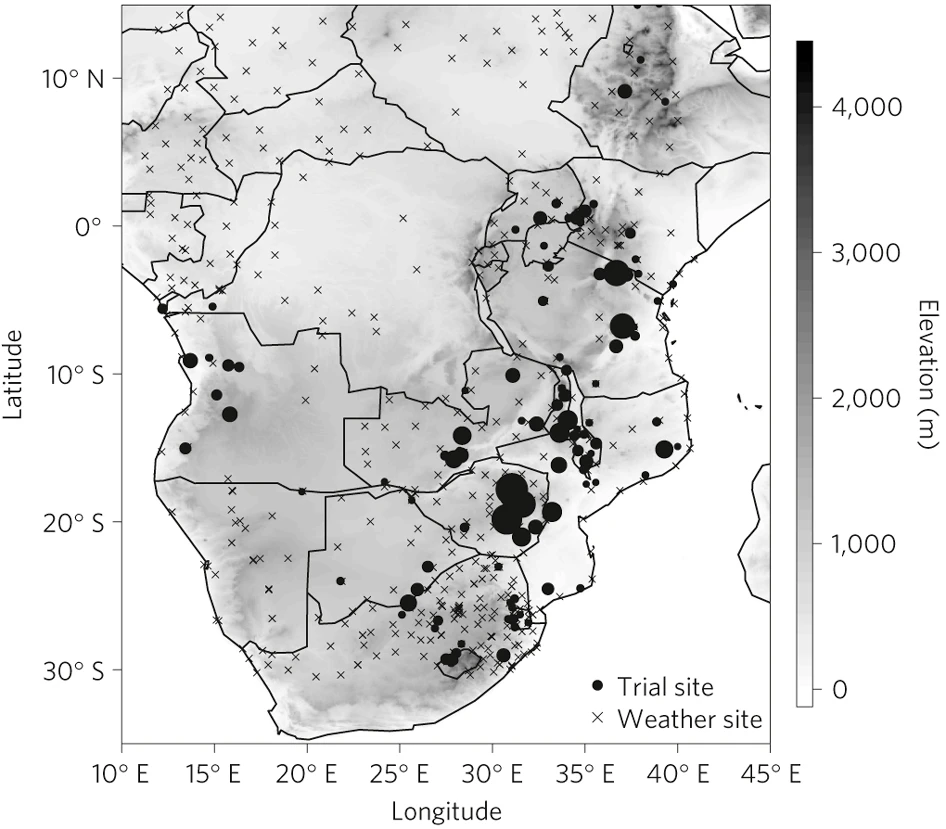
This workshop guided users through the steps to combine publicly accessible satellite imagery and weather data, and large-scale nationally representative survey data on smallholder farming in a machine learning model to estimate where crops are growing over an area. Atlas AI demonstrated the process for the African context, as documented in “Understanding the Requirements for Surveys to Support Satellite-Based Crop Type Mapping: Evidence from Sub-Saharan Africa” (2021).
About Geo4Dev
The Geospatial Analysis for Development, Geo4Dev, Initiative is run in collaboration between New Light Technologies Inc., the Center for Global Action (CEGA) out of UC Berkeley, and 3IE.
It is a hub for rigorous academic research and training that exploits geospatial data for the targeting, design, and evaluation of social and economic development programs. The initiative drives the development of new analytical tools and methods for conducting geospatial analysis across diverse sectors related to poverty and development including agriculture and food security, urbanization, climate change, humanitarian crisis, and disaster response.
The initiative brings together leading researchers, as well as government ministries, NGOs, and private enterprises to inspire novel research collaborations, share knowledge, and build capacity to utilize geospatial data, tools, and approaches.