All News>Using Big Data and machine learning to locate the poor in Nigeria | World Bank
Using Big Data and machine learning to locate the poor in Nigeria | World Bank
Financial InclusionNews |
Feb 23 2021
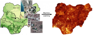
Colors in the map on the right-hand side correspond to an estimated wealth index. Source: Chi et al. (2021) for wealth estimates; National Social Safety Nets Coordinating Office for shape file; and 2018 DHS.
In a recent World Bank blog post, CEGA Faculty Director Josh Blumenstock, along with Jonathan Lain, Isabella Smyth and Tara Vishwanath, highlight the opportunity that “poverty maps,” which use satellite imagery and AI to identify a country’s poorest households, can provide for targeting aid to Nigeria’s poorest residents. This opportunity builds off a similar program that Blumenstock and his team have implemented in partnership with the Government of Togo:
“These ward-level poverty maps are useful for targeting social protection programs to communities, but digital solutions may offer further promise for identifying vulnerable households within these communities. For instance, in ongoing work being done by researchers from the University of California, Berkeley and Innovations for Poverty Action, GiveDirectly and the Government of Togo are using information collected by mobile phone operators to target cash transfers to the poorest individuals in the country. Such work requires careful attention to privacy concerns and potential exclusion errors due to heterogeneous mobile phone ownership, but offers great potential to distribute support quickly and at scale.
This poverty mapping exercise exemplifies the “moonshot” approach Nigeria can adopt to harness the rise of digital data to improve its data landscape more quickly and more cheaply. Investing in such data can help policymakers in Nigeria respond to the COVID-19 crisis and build back better.”